Mikuni night lights from space
Night Light of Mikuni (Fukui) from space (Japan) Src. Average luminocity for 10x10km area is 16.9248% and for 50x50km: 7.9001%.
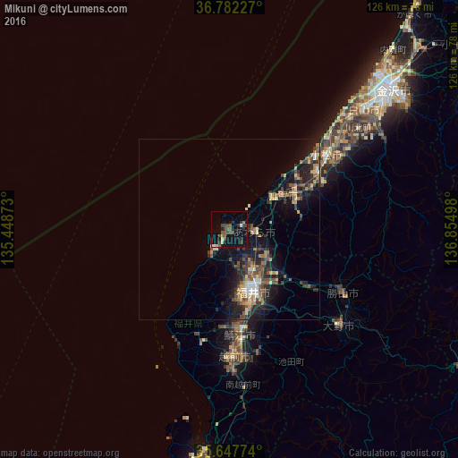

Analysis of Mikuni night lights 2016
Square area 10x10 km:
100  0.52%
0.52%
90-99 1.05%
80-89 2.27%
70-79 0.52%
60-69 1.05%
50-59 5.77%
40-49 6.64%
30-39 1.75%
20-29 4.2%
10-19 11.36%
0-9 64.86%
0.52%90-99
1.05%80-89
2.27%70-79
0.52%60-69
1.05%50-59
5.77%40-49
6.64%30-39
1.75%20-29
4.2%10-19
11.36%0-9
64.86%Square area 50x50 km:
100 0.41%
90-99 0.78%
80-89 0.86%
70-79 0.82%
60-69 1.38%
50-59 1.4%
40-49 2.07%
30-39 1.28%
20-29 2.8%
10-19 6.54%
0-9 81.65%
0.41%90-99
0.78%80-89
0.86%70-79
0.82%60-69
1.38%50-59
1.4%40-49
2.07%30-39
1.28%20-29
2.8%10-19
6.54%0-9
81.65%Clear (daylight) street map image can be seen on geolist.org.
Map coordinates:
36° 46' 56.2" North, 135° 26' 55.4" East
36° 13' 1.4" North, 136° 9' 6.7" East
35° 38' 51.9" North, 136° 51' 17.9" East
Some cities around Mikuni sort by population:
• Fukui-shi
18.1 km =11.2 mi,  159°
159°
• Komatsu
33.8 km =21 mi,  52°
52°
• Takefu
34.8 km =21.6 mi,  177°
177°
• Sabae
30.2 km =18.8 mi,  174°
174°
• Ono
40 km =24.9 mi,  131°
131°
• Maruoka
12.8 km =8 mi,  123°
123°
• Katsuyama
35.8 km =22.2 mi, 118°
• Asahi
27.3 km =17 mi,  185°
185°
1857260 (p: 23,480)
Sources (retrieved 2019-11-25):
» Earth at Night: Flat Maps 2012, 2016