Malkā night lights from space
Night Light of Malkā (Irbid) from space (Jordan) Src. Average luminocity for 10x10km area is 33.9563% and for 50x50km: 33.1288%.
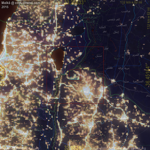
Analysis of Malkā night lights 2016
Square area 10x10 km:
 0%
0%90-99
1.92%80-89
6.82%70-79
6.12%60-69
4.2%50-59
4.9%40-49
9.27%30-39
7.17%20-29
19.76%10-19
31.12%0-9
8.74%Square area 50x50 km:
2.34%90-99
3.03%80-89
7.74%70-79
6.29%60-69
4.27%50-59
5.17%40-49
7.18%30-39
6.32%20-29
10.26%10-19
17.13%0-9
30.27%Clear (daylight) street map image can be seen on geolist.org.
Map coordinates:
33° 15' 58.8" North, 35° 2' 43.4" East
32° 40' 35.2" North, 35° 44' 54.6" East
32° 4' 57.5" North, 36° 27' 5.9" East
Some cities around Malkā sort by population:
• Aţ Ţayyibah
15.1 km =9.4 mi,  191°
191°
• Şammā
12.9 km =8 mi,  205°
205°
• Kafr Asad
9.3 km =5.8 mi,  201°
201°
• Kafr Sawm
5 km =3.1 mi,  78°
78°
• Saḩam al Kaffārāt
3.4 km =2.1 mi,  44°
44°
• Ḩātim
4.4 km =2.7 mi,  142°
142°
• Kharjā
13.2 km =8.2 mi,  98°
98°
• Qumaym
11.7 km =7.3 mi, 186°
248250 (p: 6,856)
Sources (retrieved 2019-11-25):
» Earth at Night: Flat Maps 2012, 2016