Stony Hill night lights from space
Night Light of Stony Hill (St. Andrew) from space (Jamaica) Src. Average luminocity for 10x10km area is 49.71% and for 50x50km: 17.7548%.
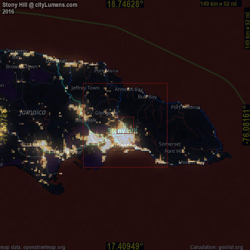
Analysis of Stony Hill night lights 2016
Square area 10x10 km:
 8.44%
8.44%90-99
10.17%80-89
11.47%70-79
5.84%60-69
5.84%50-59
2.6%40-49
7.36%30-39
9.52%20-29
11.69%10-19
17.75%0-9
9.31%Square area 50x50 km:
3.63%90-99
2.8%80-89
3.57%70-79
1.48%60-69
1.68%50-59
1.58%40-49
2.29%30-39
2.66%20-29
5.35%10-19
8.85%0-9
66.11%Clear (daylight) street map image can be seen on geolist.org.
Map coordinates:
18° 44' 46.6" North, 77° 29' 16.3" West
18° 4' 45" North, 76° 47' 5" West
17° 24' 34.2" North, 76° 4' 53.8" West
Some cities around Stony Hill sort by population:
• Kingston
9.2 km =5.7 mi,  185°
185°
• New Kingston
8 km =5 mi,  178°
178°
• Spanish Town
20.7 km =12.9 mi,  241°
241°
• Portmore
17.6 km =10.9 mi,  215°
215°
• Half Way Tree
7.6 km =4.7 mi, 191°
• Bog Walk
23.5 km =14.6 mi,  276°
276°
• Constant Spring
3.3 km =2.1 mi,  196°
196°
• Annotto Bay
21.5 km =13.4 mi,  5°
5°
3488380 (p: 8,551)
Sources (retrieved 2019-11-25):
» Earth at Night: Flat Maps 2012, 2016