Annotto Bay night lights from space
Night Light of Annotto Bay (St. Mary) from space (Jamaica) Src. Average luminocity for 10x10km area is 1.6942% and for 50x50km: 4.4665%.
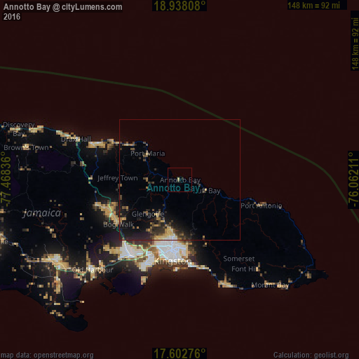
Analysis of Annotto Bay night lights 2016
Square area 10x10 km:
 0%
0%90-99
0%80-89
0.83%70-79
0%60-69
0.62%50-59
0.21%40-49
0%30-39
0%20-29
0.83%10-19
0%0-9
97.52%Square area 50x50 km:
0.1%90-99
0.23%80-89
0.76%70-79
0.52%60-69
0.63%50-59
0.45%40-49
1.19%30-39
1.05%20-29
2.12%10-19
4.09%0-9
88.86%Clear (daylight) street map image can be seen on geolist.org.
Map coordinates:
18° 56' 17.1" North, 77° 28' 6.1" West
18° 16' 18.1" North, 76° 45' 54.8" West
17° 36' 9.9" North, 76° 3' 43.6" West
Some cities around Annotto Bay sort by population:
• Kingston
30.7 km =19.1 mi,  185°
185°
• New Kingston
29.4 km =18.3 mi,  183°
183°
• Linstead
31.9 km =19.8 mi,  241°
241°
• Half Way Tree
29 km =18 mi, 187°
• Bog Walk
31.6 km =19.6 mi,  233°
233°
• Constant Spring
24.7 km =15.3 mi, 186°
• Stony Hill
21.5 km =13.4 mi, 185°
• Port Maria
17 km =10.6 mi,  309°
309°
3491556 (p: 5,504)
Sources (retrieved 2019-11-25):
» Earth at Night: Flat Maps 2012, 2016