Zevio night lights from space
Night Light of Zevio (Veneto) from space (Italy) Src. Average luminocity for 10x10km area is 42.5825% and for 50x50km: 39.7386%.
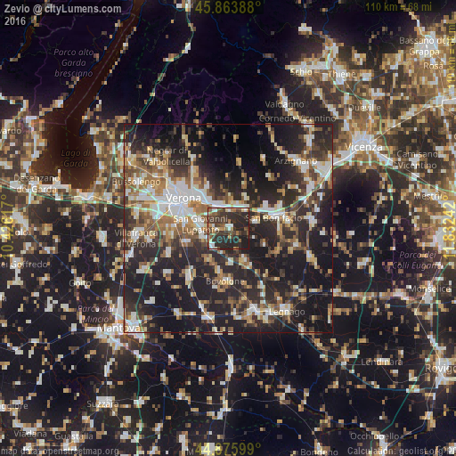
Analysis of Zevio night lights 2016
Square area 10x10 km:
 4.76%
4.76%90-99
4.44%80-89
3.02%70-79
3.33%60-69
6.67%50-59
5.87%40-49
12.38%30-39
16.98%20-29
33.49%10-19
9.05%0-9
0%Square area 50x50 km:
6.03%90-99
7.02%80-89
3.88%70-79
4.14%60-69
5.3%50-59
6.23%40-49
6.39%30-39
6.71%20-29
18.29%10-19
26.65%0-9
9.36%Clear (daylight) street map image can be seen on geolist.org.
Map coordinates:
45° 51' 50" North, 10° 25' 34.2" East
45° 22' 19.5" North, 11° 7' 45.4" East
44° 52' 33.6" North, 11° 49' 56.7" East
Some cities around Zevio sort by population:
• San Giovanni Lupatoto
6.7 km =4.2 mi,  279°
279°
• San Bonifacio
11.6 km =7.2 mi,  76°
76°
• Bovolone
12.3 km =7.6 mi,  184°
184°
• San Martino Buon Albergo
6 km =3.7 mi,  334°
334°
• Lavagno
7.4 km =4.6 mi,  2°
2°
• Caldiero
6 km =3.7 mi,  38°
38°
• Montorio
10.8 km =6.7 mi, 332°
• Soave
10.5 km =6.5 mi,  59°
59°
3163878 (p: 12,035)
Sources (retrieved 2019-11-25):
» Earth at Night: Flat Maps 2012, 2016