San Bonifacio night lights from space
Night Light of San Bonifacio (Veneto) from space (Italy) Src. Average luminocity for 10x10km area is 51.9857% and for 50x50km: 36.4976%.
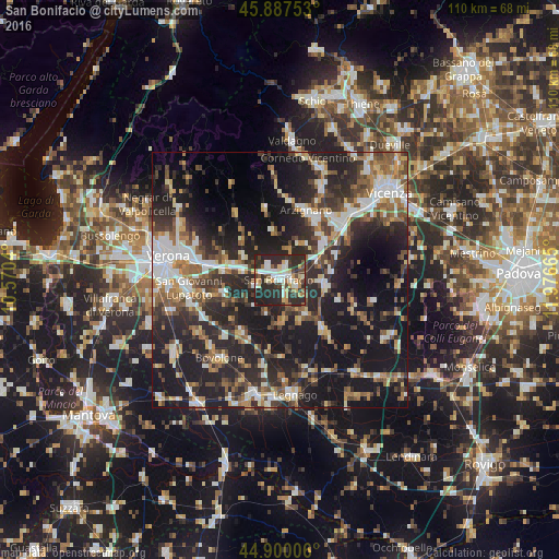
Analysis of San Bonifacio night lights 2016
Square area 10x10 km:
 7.78%
7.78%90-99
13.33%80-89
5.08%70-79
7.78%60-69
4.6%50-59
4.29%40-49
6.67%30-39
9.37%20-29
36.83%10-19
4.29%0-9
0%Square area 50x50 km:
5.32%90-99
6.07%80-89
3.48%70-79
3.93%60-69
4.52%50-59
5.66%40-49
6.31%30-39
6.4%20-29
16.51%10-19
27.56%0-9
14.24%Clear (daylight) street map image can be seen on geolist.org.
Map coordinates:
45° 53' 15.1" North, 10° 34' 13.4" East
45° 23' 45.4" North, 11° 16' 24.7" East
44° 54' 0.2" North, 11° 58' 35.9" East
Some cities around San Bonifacio sort by population:
• Lonigo
8.7 km =5.4 mi,  97°
97°
• Zevio
11.6 km =7.2 mi,  256°
256°
• San Martino Buon Albergo
14.2 km =8.8 mi,  281°
281°
• Lavagno
11.9 km =7.4 mi,  293°
293°
• Caldiero
7.8 km =4.8 mi, 285°
• Monteforte d'Alpone
2.8 km =1.7 mi,  17°
17°
• Montebello Vicentino
11 km =6.8 mi,  50°
50°
• Soave
3.4 km =2.1 mi,  320°
320°
3168514 (p: 17,347)
Sources (retrieved 2019-11-25):
» Earth at Night: Flat Maps 2012, 2016