Lavagno night lights from space
Night Light of Lavagno (Veneto) from space (Italy) Src. Average luminocity for 10x10km area is 47.4635% and for 50x50km: 35.9702%.
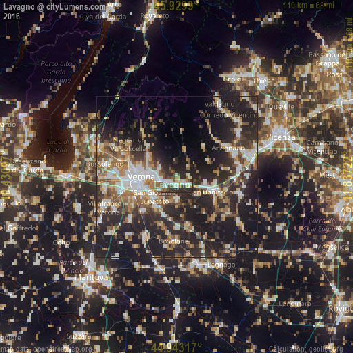
Analysis of Lavagno night lights 2016
Square area 10x10 km:
 7.62%
7.62%90-99
9.68%80-89
5.71%70-79
1.59%60-69
6.35%50-59
6.03%40-49
11.75%30-39
7.62%20-29
28.41%10-19
15.24%0-9
0%Square area 50x50 km:
5.33%90-99
6.21%80-89
3.53%70-79
3.82%60-69
4.9%50-59
5.58%40-49
5.71%30-39
6.2%20-29
17.15%10-19
23.06%0-9
18.51%Clear (daylight) street map image can be seen on geolist.org.
Map coordinates:
45° 55' 47.6" North, 10° 25' 51.5" East
45° 26' 19.3" North, 11° 8' 2.7" East
44° 56' 35.4" North, 11° 50' 14" East
Some cities around Lavagno sort by population:
• Verona
11.7 km =7.3 mi,  265°
265°
• San Giovanni Lupatoto
9.4 km =5.8 mi,  227°
227°
• Zevio
7.4 km =4.6 mi,  182°
182°
• San Martino Buon Albergo
3.6 km =2.2 mi,  236°
236°
• Caldiero
4.3 km =2.7 mi,  128°
128°
• Montorio
5.7 km =3.5 mi,  292°
292°
• Monteforte d'Alpone
11.9 km =7.4 mi,  99°
99°
• Soave
9 km =5.6 mi, 103°
6534600 (p: 5,964)
Sources (retrieved 2019-11-25):
» Earth at Night: Flat Maps 2012, 2016