Montorio night lights from space
Night Light of Montorio (Veneto) from space (Italy) Src. Average luminocity for 10x10km area is 57.7317% and for 50x50km: 35.1841%.
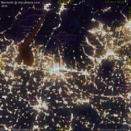
Analysis of Montorio night lights 2016
Square area 10x10 km:
 14.44%
90-99
14.29%80-89
3.65%70-79
6.03%60-69
7.78%50-59
10.79%40-49
7.3%30-39
5.71%20-29
14.76%10-19
11.9%0-9
3.33%Square area 50x50 km:
5.01%90-99
6%80-89
3.66%70-79
3.82%60-69
5.14%50-59
5.55%40-49
5.9%30-39
6.05%20-29
16.38%10-19
20.09%0-9
22.41%Clear (daylight) street map image can be seen on geolist.org.
Map coordinates:
45° 56' 57.5" North, 10° 21' 46" East
45° 27' 29.7" North, 11° 3' 57.2" East
44° 57' 46.5" North, 11° 46' 8.5" East
Some cities around Montorio sort by population:
• Verona
7.1 km =4.4 mi,  243°
243°
• San Giovanni Lupatoto
8.6 km =5.3 mi,  191°
191°
• Zevio
10.8 km =6.7 mi,  152°
152°
• San Martino Buon Albergo
4.8 km =3 mi, 150°
• Beccacivetta-Azzano
12.4 km =7.7 mi,  221°
221°
• Lavagno
5.7 km =3.5 mi,  112°
112°
• Caldiero
10 km =6.2 mi,  119°
119°
• Arbizzano-Santa Maria
10.7 km =6.6 mi,  292°
292°
3172642 (p: 5,330)
Sources (retrieved 2019-11-25):
» Earth at Night: Flat Maps 2012, 2016