Volterra night lights from space
Night Light of Volterra (Tuscany) from space (Italy) Src. Average luminocity for 10x10km area is 4.9635% and for 50x50km: 6.5419%.
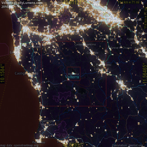
Analysis of Volterra night lights 2016
Square area 10x10 km:
 0.32%
0.32%90-99
1.9%80-89
0%70-79
0.63%60-69
0.32%50-59
0.79%40-49
1.11%30-39
0%20-29
1.11%10-19
1.11%0-9
92.7%Square area 50x50 km:
0.45%90-99
1.08%80-89
0.98%70-79
0.54%60-69
0.54%50-59
0.81%40-49
0.9%30-39
1.06%20-29
1.72%10-19
5.47%0-9
86.45%Clear (daylight) street map image can be seen on geolist.org.
Map coordinates:
43° 54' 40.4" North, 10° 9' 30.2" East
43° 24' 9" North, 10° 51' 41.5" East
42° 53' 22.2" North, 11° 33' 52.7" East
Some cities around Volterra sort by population:
• Cecina
29.8 km =18.5 mi,  248°
248°
• Poggibonsi
24.3 km =15.1 mi,  71°
71°
• San Miniato
30.8 km =19.1 mi,  358°
358°
• Colle di Val d'Elsa
21.6 km =13.4 mi,  84°
84°
• Ponsacco
31 km =19.3 mi,  322°
322°
• Certaldo
21.6 km =13.4 mi,  41°
41°
• Castelfiorentino
24.6 km =15.3 mi,  20°
20°
• Tavarnelle Val di Pesa
30.6 km =19 mi,  54°
54°
3163962 (p: 6,864)
Sources (retrieved 2019-11-25):
» Earth at Night: Flat Maps 2012, 2016