Vitinia night lights from space
Night Light of Vitinia (Latium) from space (Italy) Src. Average luminocity for 10x10km area is 80.0292% and for 50x50km: 50.417%.
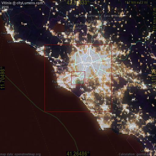
Analysis of Vitinia night lights 2016
Square area 10x10 km:
 28.9%
28.9%90-99
23.86%80-89
7.47%70-79
5.52%60-69
10.23%50-59
8.77%40-49
7.14%30-39
6.98%20-29
1.14%10-19
0%0-9
0%Square area 50x50 km:
15.52%90-99
13.04%80-89
5%70-79
5.63%60-69
5.45%50-59
5.63%40-49
4.94%30-39
5.24%20-29
6.35%10-19
8.69%0-9
24.52%Clear (daylight) street map image can be seen on geolist.org.
Map coordinates:
42° 18' 48" North, 11° 42' 17.9" East
41° 47' 28.5" North, 12° 24' 29.2" East
41° 15' 53.5" North, 13° 6' 40.4" East
Some cities around Vitinia sort by population:
• Rome
14.1 km =8.8 mi,  37°
37°
• Acilia-Castel Fusano-Ostia Antica
7.1 km =4.4 mi,  244°
244°
• Lido di Ostia
12.7 km =7.9 mi, 238°
• Fiumicino-Isola Sacra
14.4 km =8.9 mi,  260°
260°
• Casal Palocco
6.9 km =4.3 mi,  226°
226°
• La Massimina-Casal Lumbroso
10.1 km =6.3 mi,  335°
335°
• Selcetta
6.3 km =3.9 mi,  117°
117°
• Vatican City, VA
13 km =8.1 mi,  17°
17°
6698334 (p: 5,799)
Sources (retrieved 2019-11-25):
» Earth at Night: Flat Maps 2012, 2016