Vatican City night lights from space
Night Light of Vatican City from space (Vatican) Src. Average luminocity for 10x10km area is 98.754% and for 50x50km: 55.3116%.
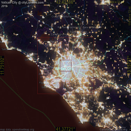
Analysis of Vatican City night lights 2016
Square area 10x10 km:
 66.03%
90-99
30.79%80-89
1.59%70-79
0.95%60-69
0.63%50-59
0%40-49
0%30-39
0%20-29
0%10-19
0%0-9
0%Square area 50x50 km:
15.57%90-99
13.51%80-89
5.82%70-79
5.94%60-69
6.55%50-59
6.84%40-49
5.61%30-39
5.83%20-29
10.37%10-19
12.45%0-9
11.51%Clear (daylight) street map image can be seen on geolist.org.
Map coordinates:
42° 25' 25.9" North, 11° 45' 3.7" East
41° 54' 9.6" North, 12° 27' 14.9" East
41° 22' 38" North, 13° 9' 26.2" East
Some cities around Vatican City sort by population:
• Rome, IT
4.9 km =3 mi,  104°
104°
• Ciampino, IT
16.7 km =10.4 mi,  132°
132°
• Tor Lupara, IT
17.2 km =10.7 mi,  52°
52°
• La Massimina-Casal Lumbroso, IT
8.7 km =5.4 mi,  247°
247°
• Marco Simone, IT
17.1 km =10.6 mi,  69°
69°
• Selcetta, IT
15.4 km =9.6 mi,  173°
173°
• Ara Nova, IT
18.1 km =11.2 mi,  280°
280°
• Vitinia, IT
13 km =8.1 mi,  197°
197°
6691831 (p: 829)
Sources (retrieved 2019-11-25):
» Earth at Night: Flat Maps 2012, 2016