Selcetta night lights from space
Night Light of Selcetta (Latium) from space (Italy) Src. Average luminocity for 10x10km area is 65.6916% and for 50x50km: 53.9833%.
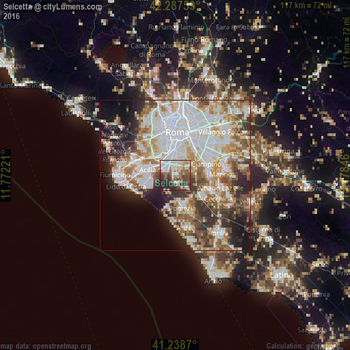
Analysis of Selcetta night lights 2016
Square area 10x10 km:
 15.91%
90-99
17.86%80-89
6.82%70-79
4.55%60-69
6.01%50-59
10.71%40-49
16.07%30-39
10.39%20-29
11.69%10-19
0%0-9
0%Square area 50x50 km:
15.63%90-99
13.45%80-89
5.65%70-79
5.99%60-69
6.52%50-59
6.84%40-49
6.02%30-39
5.92%20-29
7.66%10-19
8.87%0-9
17.46%Clear (daylight) street map image can be seen on geolist.org.
Map coordinates:
42° 17' 15.3" North, 11° 46' 20" East
41° 45' 55" North, 12° 28' 31.2" East
41° 14' 19.3" North, 13° 10' 42.5" East
Some cities around Selcetta sort by population:
• Rome
14.4 km =8.9 mi,  11°
11°
• Acilia-Castel Fusano-Ostia Antica
12 km =7.5 mi,  268°
268°
• Marino
15.3 km =9.5 mi,  88°
88°
• Ciampino
11.2 km =7 mi,  69°
69°
• Casal Palocco
10.8 km =6.7 mi,  260°
260°
• Pomezia
10.9 km =6.8 mi,  168°
168°
• Vitinia
6.3 km =3.9 mi,  297°
297°
• Vatican City, VA
15.4 km =9.6 mi,  353°
353°
8948759 (p: 6,772)
Sources (retrieved 2019-11-25):
» Earth at Night: Flat Maps 2012, 2016