Villadossola night lights from space
Night Light of Villadossola (Piedmont) from space (Italy) Src. Average luminocity for 10x10km area is 19.9503% and for 50x50km: 4.2054%.
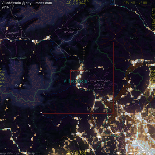
Analysis of Villadossola night lights 2016
Square area 10x10 km:
 1.7%
1.7%90-99
4.26%80-89
2.27%70-79
1.28%60-69
1.14%50-59
2.98%40-49
2.56%30-39
2.84%20-29
4.83%10-19
27.7%0-9
48.44%Square area 50x50 km:
0.22%90-99
0.62%80-89
0.28%70-79
0.46%60-69
0.52%50-59
0.58%40-49
0.89%30-39
0.76%20-29
1.01%10-19
4.4%0-9
90.25%Clear (daylight) street map image can be seen on geolist.org.
Map coordinates:
46° 33' 23.2" North, 7° 33' 50.3" East
46° 4' 14.9" North, 8° 16' 1.5" East
45° 34' 51" North, 8° 58' 12.8" East
Some cities around Villadossola sort by population:
• Verbania
27.6 km =17.1 mi,  127°
127°
• Pallanza-Intra-Suna
27.7 km =17.2 mi,  122°
122°
• Domodossola
5.5 km =3.4 mi,  21°
21°
• Omegna
23.8 km =14.8 mi,  153°
153°
• Laveno
32.7 km =20.3 mi, 123°
• Naters, CH
35.5 km =22.1 mi,  322°
322°
• Gravellona Toce
20.3 km =12.6 mi,  141°
141°
• Varallo
28.6 km =17.8 mi,  181°
181°
3164253 (p: 6,633)
Sources (retrieved 2019-11-25):
» Earth at Night: Flat Maps 2012, 2016