Domodossola night lights from space
Night Light of Domodossola (Piedmont) from space (Italy) Src. Average luminocity for 10x10km area is 21.0199% and for 50x50km: 3.9932%.
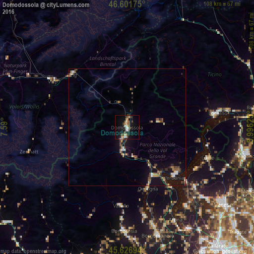
Analysis of Domodossola night lights 2016
Square area 10x10 km:
 0.85%
0.85%90-99
4.26%80-89
3.27%70-79
2.41%60-69
1.56%50-59
2.84%40-49
3.84%30-39
3.55%20-29
3.84%10-19
21.45%0-9
52.13%Square area 50x50 km:
0.25%90-99
0.61%80-89
0.28%70-79
0.39%60-69
0.54%50-59
0.58%40-49
0.87%30-39
0.7%20-29
0.85%10-19
4.48%0-9
90.45%Clear (daylight) street map image can be seen on geolist.org.
Map coordinates:
46° 36' 6.3" North, 7° 35' 24" East
46° 6' 59.4" North, 8° 17' 35.3" East
45° 37' 37" North, 8° 59' 46.5" East
Some cities around Domodossola sort by population:
• Verbania
29.5 km =18.3 mi,  137°
137°
• Pallanza-Intra-Suna
29.2 km =18.1 mi,  132°
132°
• Omegna
27.7 km =17.2 mi,  161°
161°
• Laveno
34.2 km =21.3 mi, 132°
• Naters, CH
33 km =20.5 mi,  314°
314°
• Gravellona Toce
23.5 km =14.6 mi,  152°
152°
• Villadossola
5.5 km =3.4 mi,  201°
201°
• Varallo
33.8 km =21 mi,  184°
184°
3177532 (p: 17,778)
Sources (retrieved 2019-11-25):
» Earth at Night: Flat Maps 2012, 2016