Varallo night lights from space
Night Light of Varallo (Piedmont) from space (Italy) Src. Average luminocity for 10x10km area is 8.0342% and for 50x50km: 11.8977%.
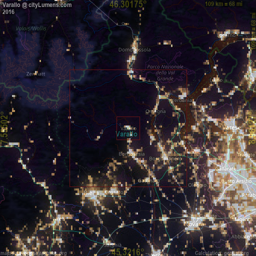
Analysis of Varallo night lights 2016
Square area 10x10 km:
 1.49%
1.49%90-99
1.19%80-89
0%70-79
1.79%60-69
0.3%50-59
0.74%40-49
1.04%30-39
0%20-29
0.6%10-19
3.27%0-9
89.58%Square area 50x50 km:
0.58%90-99
1.14%80-89
1.07%70-79
1.44%60-69
1.58%50-59
2.05%40-49
2.33%30-39
2.11%20-29
4.09%10-19
15.71%0-9
67.88%Clear (daylight) street map image can be seen on geolist.org.
Map coordinates:
46° 18' 6.3" North, 7° 33' 18.1" East
45° 48' 49.8" North, 8° 15' 29.3" East
45° 19' 17.8" North, 8° 57' 40.6" East
Some cities around Varallo sort by population:
• Verbania
25.7 km =16 mi,  62°
62°
• Borgomanero
20.4 km =12.7 mi,  128°
128°
• Omegna
13.7 km =8.5 mi, 57°
• Cossato
27.7 km =17.2 mi,  191°
191°
• Arona
24 km =14.9 mi,  104°
104°
• Borgosesia
10.5 km =6.5 mi,  172°
172°
• Gattinara
23.8 km =14.8 mi,  159°
159°
• Gravellona Toce
18.6 km =11.6 mi,  46°
46°
3164718 (p: 5,427)
Sources (retrieved 2019-11-25):
» Earth at Night: Flat Maps 2012, 2016