Villa d'Almè night lights from space
Night Light of Villa d'Almè (Lombardy) from space (Italy) Src. Average luminocity for 10x10km area is 58.8% and for 50x50km: 46.7639%.
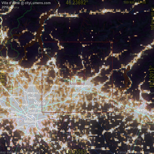
Analysis of Villa d'Almè night lights 2016
Square area 10x10 km:
 11.82%
90-99
14.09%80-89
5.61%70-79
9.39%60-69
7.27%50-59
8.03%40-49
8.33%30-39
9.39%20-29
19.39%10-19
6.67%0-9
0%Square area 50x50 km:
10.85%90-99
11.51%80-89
4.65%70-79
5.45%60-69
7.03%50-59
6.47%40-49
5.94%30-39
6.86%20-29
7.03%10-19
9.54%0-9
24.68%Clear (daylight) street map image can be seen on geolist.org.
Map coordinates:
46° 14' 12.9" North, 8° 54' 50" East
45° 44' 54.3" North, 9° 37' 1.3" East
45° 15' 20.3" North, 10° 19' 12.5" East
Some cities around Villa d'Almè sort by population:
• Ponte San Pietro
5.2 km =3.2 mi,  203°
203°
• Sorisole
2.5 km =1.6 mi,  140°
140°
• Brembate di Sopra
4.6 km =2.9 mi,  219°
219°
• Mozzo
5.6 km =3.5 mi,  186°
186°
• Ponteranica
3.2 km =2 mi,  123°
123°
• Zogno
6 km =3.7 mi,  33°
33°
• Almenno San Salvatore
1.6 km =1 mi,  275°
275°
• Almè
1.1 km =0.7 mi, 185°
3164270 (p: 6,208)
Sources (retrieved 2019-11-25):
» Earth at Night: Flat Maps 2012, 2016