Ponteranica night lights from space
Night Light of Ponteranica (Lombardy) from space (Italy) Src. Average luminocity for 10x10km area is 67.1985% and for 50x50km: 47.2379%.
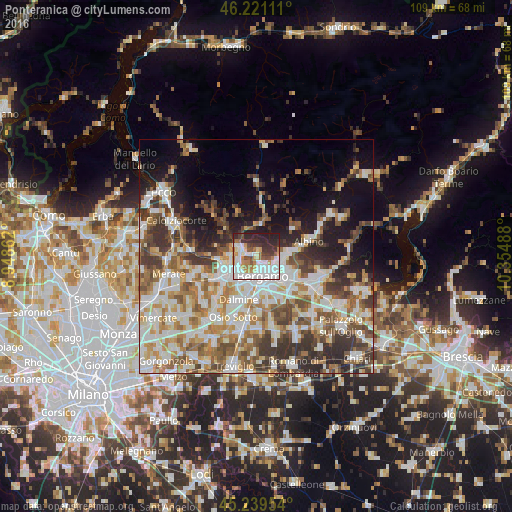
Analysis of Ponteranica night lights 2016
Square area 10x10 km:
 24.24%
90-99
16.97%80-89
3.64%70-79
7.73%60-69
6.21%50-59
6.21%40-49
4.7%30-39
10%20-29
16.52%10-19
3.79%0-9
0%Square area 50x50 km:
10.56%90-99
11.27%80-89
4.55%70-79
5.42%60-69
7.09%50-59
6.99%40-49
6.71%30-39
7.59%20-29
7.38%10-19
10%0-9
22.43%Clear (daylight) street map image can be seen on geolist.org.
Map coordinates:
46° 13' 16" North, 8° 56' 55" East
45° 43' 56.9" North, 9° 39' 6.3" East
45° 14' 22.3" North, 10° 21' 17.6" East
Some cities around Ponteranica sort by population:
• Bergamo
4.2 km =2.6 mi,  163°
163°
• Sorisole
1.1 km =0.7 mi,  263°
263°
• Torre Boldone
4.7 km =2.9 mi,  111°
111°
• Mozzo
5 km =3.1 mi,  221°
221°
• Villa d'Almè
3.2 km =2 mi,  303°
303°
• Ranica
4.9 km =3 mi,  102°
102°
• Almenno San Salvatore
4.7 km =2.9 mi,  294°
294°
• Almè
2.9 km =1.8 mi,  284°
284°
6534505 (p: 6,463)
Sources (retrieved 2019-11-25):
» Earth at Night: Flat Maps 2012, 2016