Almè night lights from space
Night Light of Almè (Lombardy) from space (Italy) Src. Average luminocity for 10x10km area is 64.1348% and for 50x50km: 47.8789%.
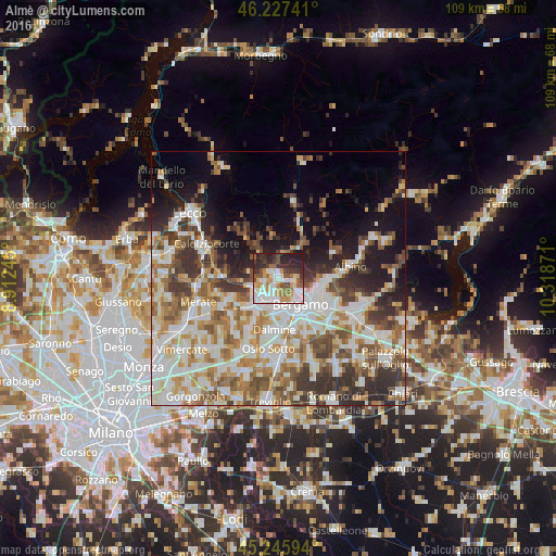
Analysis of Almè night lights 2016
Square area 10x10 km:
 16.52%
90-99
16.97%80-89
5.45%70-79
9.85%60-69
6.36%50-59
7.73%40-49
6.82%30-39
9.09%20-29
17.58%10-19
3.64%0-9
0%Square area 50x50 km:
11.15%90-99
11.83%80-89
4.71%70-79
5.56%60-69
7.2%50-59
6.59%40-49
6.17%30-39
6.99%20-29
7.35%10-19
9.54%0-9
22.92%Clear (daylight) street map image can be seen on geolist.org.
Map coordinates:
46° 13' 38.7" North, 8° 54' 44.8" East
45° 44' 19.8" North, 9° 36' 56.1" East
45° 14' 45.4" North, 10° 19' 7.4" East
Some cities around Almè sort by population:
• Ponte San Pietro
4.1 km =2.5 mi,  208°
208°
• Sorisole
1.9 km =1.2 mi,  116°
116°
• Brembate di Sopra
3.7 km =2.3 mi,  228°
228°
• Curno
5.6 km =3.5 mi,  185°
185°
• Mozzo
4.5 km =2.8 mi, 186°
• Ponteranica
2.9 km =1.8 mi,  104°
104°
• Villa d'Almè
1.1 km =0.7 mi,  5°
5°
• Almenno San Salvatore
1.9 km =1.2 mi,  309°
309°
3183260 (p: 5,660)
Sources (retrieved 2019-11-25):
» Earth at Night: Flat Maps 2012, 2016