Inzago night lights from space
Night Light of Inzago (Lombardy) from space (Italy) Src. Average luminocity for 10x10km area is 71.6727% and for 50x50km: 68.3129%.
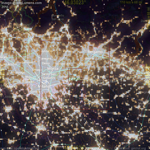
Analysis of Inzago night lights 2016
Square area 10x10 km:
 14.39%
90-99
17.88%80-89
6.52%70-79
11.97%60-69
15%50-59
17.73%40-49
8.33%30-39
6.52%20-29
1.67%10-19
0%0-9
0%Square area 50x50 km:
23.02%90-99
15.95%80-89
6.47%70-79
7.97%60-69
8.63%50-59
7.06%40-49
6.36%30-39
7.37%20-29
11.53%10-19
5.32%0-9
0.33%Clear (daylight) street map image can be seen on geolist.org.
Map coordinates:
46° 1' 48.8" North, 8° 46' 49.1" East
45° 32' 23.7" North, 9° 29' 0.3" East
45° 2' 43" North, 10° 11' 11.6" East
Some cities around Inzago sort by population:
• Gorgonzola
6.2 km =3.9 mi,  260°
260°
• Melzo
6.8 km =4.2 mi,  226°
226°
• Cassano d'Adda
2.9 km =1.8 mi,  121°
121°
• Gessate
3.7 km =2.3 mi,  284°
284°
• Vaprio d'Adda
5.1 km =3.2 mi,  37°
37°
• Fara Gera d'Adda
4.5 km =2.8 mi,  65°
65°
• Cambiago
5.9 km =3.7 mi,  320°
320°
• Pozzuolo Martesana
3.6 km =2.2 mi,  216°
216°
3175491 (p: 7,973)
Sources (retrieved 2019-11-25):
» Earth at Night: Flat Maps 2012, 2016