Ugento night lights from space
Night Light of Ugento (Apulia) from space (Italy) Src. Average luminocity for 10x10km area is 33.8656% and for 50x50km: 19.7086%.
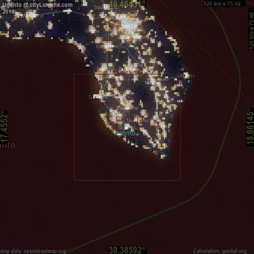
Analysis of Ugento night lights 2016
Square area 10x10 km:
100  2.04%
2.04%
90-99 5.61%
80-89 4.59%
70-79 4.93%
60-69 4.59%
50-59 2.38%
40-49 2.89%
30-39 6.12%
20-29 20.07%
10-19 45.58%
0-9 1.19%
2.04%90-99
5.61%80-89
4.59%70-79
4.93%60-69
4.59%50-59
2.38%40-49
2.89%30-39
6.12%20-29
20.07%10-19
45.58%0-9
1.19%Square area 50x50 km:
100 1.71%
90-99 3.8%
80-89 2.66%
70-79 1.98%
60-69 2.67%
50-59 1.6%
40-49 1.79%
30-39 4.32%
20-29 12.85%
10-19 14.7%
0-9 51.94%
1.71%90-99
3.8%80-89
2.66%70-79
1.98%60-69
2.67%50-59
1.6%40-49
1.79%30-39
4.32%20-29
12.85%10-19
14.7%0-9
51.94%Clear (daylight) street map image can be seen on geolist.org.
Map coordinates:
40° 27' 51.5" North, 17° 27' 18.7" East
39° 55' 38.1" North, 18° 9' 30" East
39° 23' 9.3" North, 18° 51' 41.2" East
Some cities around Ugento sort by population:
• Casarano
9.4 km =5.8 mi,  2°
2°
• Taviano
9 km =5.6 mi,  313°
313°
• Matino
11.7 km =7.3 mi,  350°
350°
• Taurisano
5.9 km =3.7 mi,  55°
55°
• Racale
6.8 km =4.2 mi,  303°
303°
• Ruffano
9.9 km =6.2 mi,  52°
52°
• Melissano
6 km =3.7 mi,  328°
328°
• Presicce
9.4 km =5.8 mi,  108°
108°
2522833 (p: 8,875)
Sources (retrieved 2019-11-25):
» Earth at Night: Flat Maps 2012, 2016