Tortoreto Lido night lights from space
Night Light of Tortoreto Lido (Abruzzo) from space (Italy) Src. Average luminocity for 10x10km area is 45.9379% and for 50x50km: 22.1944%.
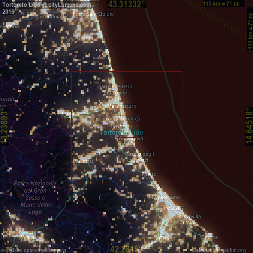
Analysis of Tortoreto Lido night lights 2016
Square area 10x10 km:
 9.7%
9.7%90-99
9.09%80-89
5.61%70-79
3.33%60-69
3.94%50-59
6.36%40-49
9.09%30-39
6.67%20-29
21.06%10-19
15.91%0-9
9.24%Square area 50x50 km:
2.41%90-99
4.07%80-89
2.41%70-79
2.4%60-69
2.69%50-59
2.83%40-49
3.44%30-39
4.29%20-29
10.79%10-19
17.99%0-9
46.69%Clear (daylight) street map image can be seen on geolist.org.
Map coordinates:
43° 18' 48" North, 13° 14' 20.1" East
42° 47' 58.4" North, 13° 56' 31.4" East
42° 16' 53.4" North, 14° 38' 42.6" East
Some cities around Tortoreto Lido sort by population:
• San Benedetto del Tronto
18.3 km =11.4 mi,  343°
343°
• Giulianova
5.5 km =3.4 mi,  158°
158°
• Roseto degli Abruzzi
15.4 km =9.6 mi, 157°
• Alba Adriatica
3.8 km =2.4 mi, 339°
• Martinsicuro
9.3 km =5.8 mi,  345°
345°
• Centobuchi
13.1 km =8.1 mi,  324°
324°
• Sant'Egidio alla Vibrata
18.1 km =11.2 mi,  276°
276°
• San Nicolò a Tordino
16.5 km =10.3 mi,  225°
225°
6589958 (p: 6,203)
Sources (retrieved 2019-11-25):
» Earth at Night: Flat Maps 2012, 2016