Roseto degli Abruzzi night lights from space
Night Light of Roseto degli Abruzzi (Abruzzo) from space (Italy) Src. Average luminocity for 10x10km area is 37.9227% and for 50x50km: 21.5358%.
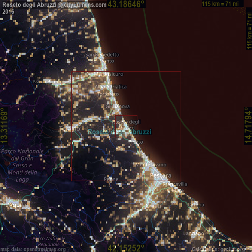
Analysis of Roseto degli Abruzzi night lights 2016
Square area 10x10 km:
 5.3%
5.3%90-99
8.48%80-89
3.03%70-79
1.82%60-69
6.97%50-59
4.85%40-49
4.39%30-39
8.18%20-29
19.7%10-19
22.88%0-9
14.39%Square area 50x50 km:
2.85%90-99
4.21%80-89
1.98%70-79
2.26%60-69
2.67%50-59
2.78%40-49
3.37%30-39
3.73%20-29
9.84%10-19
14.66%0-9
51.65%Clear (daylight) street map image can be seen on geolist.org.
Map coordinates:
43° 11' 11.3" North, 13° 18' 42.1" East
42° 40' 17.9" North, 14° 0' 53.3" East
42° 9' 9.1" North, 14° 43' 4.6" East
Some cities around Roseto degli Abruzzi sort by population:
• Montesilvano Marina
20.8 km =12.9 mi,  149°
149°
• Giulianova
10 km =6.2 mi,  336°
336°
• Silvi
15.9 km =9.9 mi, 148°
• Alba Adriatica
19.2 km =11.9 mi, 337°
• Tortoreto Lido
15.4 km =9.6 mi, 337°
• Atri
10.8 km =6.7 mi,  191°
191°
• Pineto
8.2 km =5.1 mi, 148°
• San Nicolò a Tordino
18 km =11.2 mi,  278°
278°
3168936 (p: 16,538)
Sources (retrieved 2019-11-25):
» Earth at Night: Flat Maps 2012, 2016