Alba Adriatica night lights from space
Night Light of Alba Adriatica (Abruzzo) from space (Italy) Src. Average luminocity for 10x10km area is 48.4864% and for 50x50km: 21.8176%.
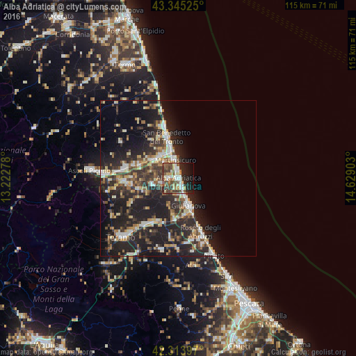
Analysis of Alba Adriatica night lights 2016
Square area 10x10 km:
 8.64%
8.64%90-99
8.18%80-89
6.06%70-79
5.3%60-69
5.45%50-59
10%40-49
10.76%30-39
8.48%20-29
14.55%10-19
14.85%0-9
7.73%Square area 50x50 km:
2.43%90-99
4.04%80-89
2.42%70-79
2.35%60-69
2.56%50-59
2.78%40-49
3.45%30-39
4.16%20-29
10.69%10-19
16.23%0-9
48.89%Clear (daylight) street map image can be seen on geolist.org.
Map coordinates:
43° 20' 42.9" North, 13° 13' 22" East
42° 49' 54.3" North, 13° 55' 33.2" East
42° 18' 50.3" North, 14° 37' 44.5" East
Some cities around Alba Adriatica sort by population:
• San Benedetto del Tronto
14.5 km =9 mi,  343°
343°
• Giulianova
9.3 km =5.8 mi,  159°
159°
• Grottammare
17.3 km =10.7 mi, 344°
• Martinsicuro
5.5 km =3.4 mi,  349°
349°
• Centobuchi
9.5 km =5.9 mi,  318°
318°
• Sant'Egidio alla Vibrata
16.7 km =10.4 mi,  264°
264°
• Castel di Lama
17.2 km =10.7 mi,  282°
282°
• Tortoreto Lido
3.8 km =2.4 mi, 159°
6534273 (p: 11,165)
Sources (retrieved 2019-11-25):
» Earth at Night: Flat Maps 2012, 2016