Todi night lights from space
Night Light of Todi (Umbria) from space (Italy) Src. Average luminocity for 10x10km area is 7.0167% and for 50x50km: 8.7422%.
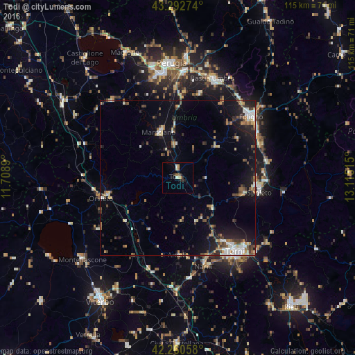
Analysis of Todi night lights 2016
Square area 10x10 km:
 0.45%
0.45%90-99
0.76%80-89
1.21%70-79
0.76%60-69
1.82%50-59
0.45%40-49
0%30-39
1.97%20-29
1.67%10-19
1.21%0-9
89.7%Square area 50x50 km:
1.06%90-99
1.26%80-89
0.83%70-79
0.79%60-69
1.14%50-59
1.04%40-49
1.48%30-39
1.32%20-29
2.41%10-19
5.87%0-9
82.81%Clear (daylight) street map image can be seen on geolist.org.
Map coordinates:
43° 17' 33.9" North, 11° 42' 32" East
42° 46' 43.7" North, 12° 24' 43.3" East
42° 15' 38.1" North, 13° 6' 54.5" East
Some cities around Todi sort by population:
• Terni
30.5 km =19 mi,  141°
141°
• Foligno
30.7 km =19.1 mi,  50°
50°
• Spoleto
27 km =16.8 mi,  99°
99°
• Marsciano
16.6 km =10.3 mi,  342°
342°
• Amelia
25.3 km =15.7 mi,  178°
178°
• Orvieto
25.3 km =15.7 mi,  254°
254°
• Narni
30.3 km =18.8 mi,  161°
161°
• Narni Scalo
28.3 km =17.6 mi, 162°
3165612 (p: 5,620)
Sources (retrieved 2019-11-25):
» Earth at Night: Flat Maps 2012, 2016