Orvieto night lights from space
Night Light of Orvieto (Umbria) from space (Italy) Src. Average luminocity for 10x10km area is 13.7197% and for 50x50km: 4.6055%.
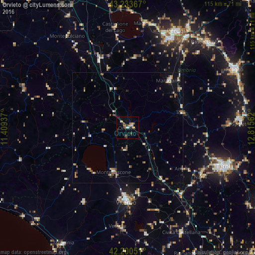
Analysis of Orvieto night lights 2016
Square area 10x10 km:
 1.21%
1.21%90-99
1.21%80-89
2.27%70-79
1.52%60-69
1.67%50-59
2.73%40-49
2.73%30-39
1.21%20-29
2.27%10-19
1.97%0-9
81.21%Square area 50x50 km:
0.28%90-99
0.68%80-89
0.58%70-79
0.52%60-69
0.66%50-59
0.66%40-49
0.83%30-39
0.66%20-29
0.75%10-19
1.05%0-9
93.33%Clear (daylight) street map image can be seen on geolist.org.
Map coordinates:
43° 14' 1.2" North, 11° 24' 33.7" East
42° 43' 9.3" North, 12° 6' 45" East
42° 12' 1.8" North, 12° 48' 56.2" East
Some cities around Orvieto sort by population:
• Viterbo
33.3 km =20.7 mi,  180°
180°
• Montefiascone
20.7 km =12.9 mi,  198°
198°
• Marsciano
29.7 km =18.5 mi,  40°
40°
• Tuscania
38.9 km =24.2 mi,  210°
210°
• Todi
25.3 km =15.7 mi,  74°
74°
• Soriano nel Cimino
34.9 km =21.7 mi,  163°
163°
• Amelia
31.3 km =19.4 mi,  126°
126°
• Narni Scalo
38.8 km =24.1 mi,  121°
121°
3171874 (p: 5,440)
Sources (retrieved 2019-11-25):
» Earth at Night: Flat Maps 2012, 2016