Narni Scalo night lights from space
Night Light of Narni Scalo (Umbria) from space (Italy) Src. Average luminocity for 10x10km area is 25.019% and for 50x50km: 10.5983%.
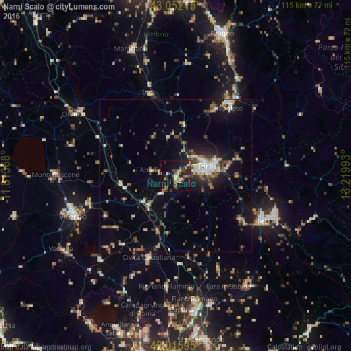
Analysis of Narni Scalo night lights 2016
Square area 10x10 km:
 0.48%
0.48%90-99
2.22%80-89
1.11%70-79
4.13%60-69
5.08%50-59
3.81%40-49
6.67%30-39
2.7%20-29
10.32%10-19
37.78%0-9
25.71%Square area 50x50 km:
1.02%90-99
1.49%80-89
1%70-79
0.98%60-69
1.36%50-59
1.48%40-49
1.89%30-39
1.71%20-29
2.88%10-19
7.08%0-9
79.11%Clear (daylight) street map image can be seen on geolist.org.
Map coordinates:
43° 3' 7.7" North, 11° 48' 49.2" East
42° 32' 10.3" North, 12° 31' 0.5" East
42° 0' 57.4" North, 13° 13' 11.7" East
Some cities around Narni Scalo sort by population:
• Terni
10.8 km =6.7 mi,  73°
73°
• Rieti
31.5 km =19.6 mi,  117°
117°
• Spoleto
29.1 km =18.1 mi,  38°
38°
• Civita Castellana
28.5 km =17.7 mi,  198°
198°
• Todi
28.3 km =17.6 mi,  342°
342°
• Soriano nel Cimino
26.6 km =16.5 mi,  240°
240°
• Amelia
8.1 km =5 mi,  282°
282°
• Fabrica di Roma
28.7 km =17.8 mi,  218°
218°
3172376 (p: 5,010)
Sources (retrieved 2019-11-25):
» Earth at Night: Flat Maps 2012, 2016