Narni night lights from space
Night Light of Narni (Umbria) from space (Italy) Src. Average luminocity for 10x10km area is 25.2619% and for 50x50km: 10.6919%.
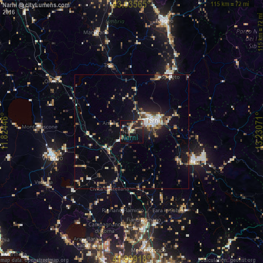
Analysis of Narni night lights 2016
Square area 10x10 km:
 0.95%
0.95%90-99
3.02%80-89
1.43%70-79
3.17%60-69
3.81%50-59
4.13%40-49
7.94%30-39
3.97%20-29
8.57%10-19
33.81%0-9
29.21%Square area 50x50 km:
0.96%90-99
1.46%80-89
0.97%70-79
1.07%60-69
1.4%50-59
1.53%40-49
1.9%30-39
1.76%20-29
2.92%10-19
7.11%0-9
78.91%Clear (daylight) street map image can be seen on geolist.org.
Map coordinates:
43° 2' 8.3" North, 11° 49' 28.1" East
42° 31' 10.4" North, 12° 31' 39.3" East
41° 59' 57" North, 13° 13' 50.6" East
Some cities around Narni sort by population:
• Terni
10.7 km =6.6 mi,  62°
62°
• Rieti
29.9 km =18.6 mi,  115°
115°
• Spoleto
30.1 km =18.7 mi,  35°
35°
• Civita Castellana
27 km =16.8 mi,  201°
201°
• Todi
30.3 km =18.8 mi,  341°
341°
• Soriano nel Cimino
26.6 km =16.5 mi,  244°
244°
• Amelia
9.5 km =5.9 mi,  292°
292°
• Fabrica di Roma
27.9 km =17.3 mi,  222°
222°
3172377 (p: 5,279)
Sources (retrieved 2019-11-25):
» Earth at Night: Flat Maps 2012, 2016