Sant'Egidio del Monte Albino night lights from space
Night Light of Sant'Egidio del Monte Albino (Campania) from space (Italy) Src. Average luminocity for 10x10km area is 73.8896% and for 50x50km: 42.242%.
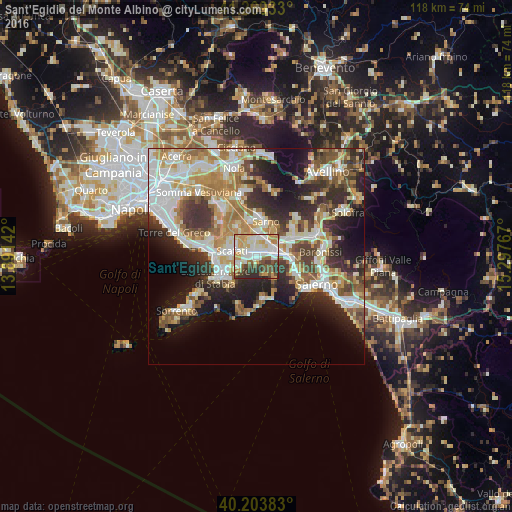
Analysis of Sant'Egidio del Monte Albino night lights 2016
Square area 10x10 km:
 17.86%
90-99
22.08%80-89
8.12%70-79
15.91%60-69
5.84%50-59
6.49%40-49
9.42%30-39
8.28%20-29
6.01%10-19
0%0-9
0%Square area 50x50 km:
8.2%90-99
9.62%80-89
5.01%70-79
5.82%60-69
6.68%50-59
5.74%40-49
4.47%30-39
6.59%20-29
9.42%10-19
11.61%0-9
26.84%Clear (daylight) street map image can be seen on geolist.org.
Map coordinates:
41° 16' 9.6" North, 13° 53' 29.1" East
40° 44' 19.4" North, 14° 35' 40.3" East
40° 12' 13.8" North, 15° 17' 51.6" East
Some cities around Sant'Egidio del Monte Albino sort by population:
• Scafati
5.4 km =3.4 mi,  296°
296°
• Nocera Inferiore
4.4 km =2.7 mi,  80°
80°
• Pagani
1.7 km =1.1 mi, 77°
• Angri
2 km =1.2 mi,  268°
268°
• Nocera Superiore
6.7 km =4.2 mi,  86°
86°
• San Marzano sul Sarno
4.5 km =2.8 mi,  344°
344°
• San Valentino Torio
5.9 km =3.7 mi,  7°
7°
• Lettere
5.6 km =3.5 mi,  228°
228°
6534271 (p: 7,564)
Sources (retrieved 2019-11-25):
» Earth at Night: Flat Maps 2012, 2016