San Valentino Torio night lights from space
Night Light of San Valentino Torio (Campania) from space (Italy) Src. Average luminocity for 10x10km area is 79.7679% and for 50x50km: 46.9039%.
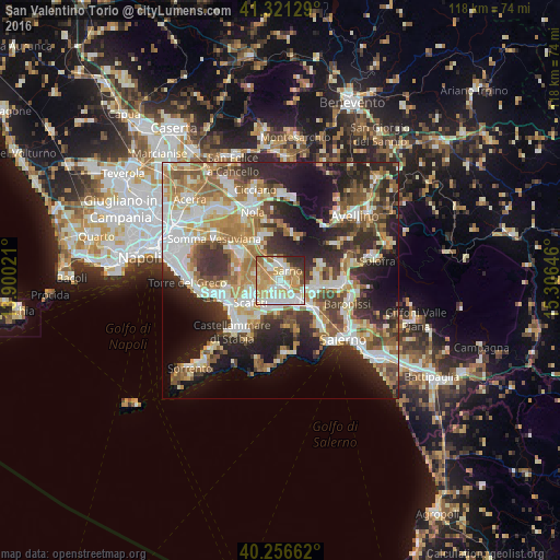
Analysis of San Valentino Torio night lights 2016
Square area 10x10 km:
 16.88%
90-99
24.19%80-89
13.8%70-79
18.18%60-69
15.42%50-59
2.44%40-49
1.3%30-39
3.57%20-29
4.22%10-19
0%0-9
0%Square area 50x50 km:
8.23%90-99
10.16%80-89
5.5%70-79
6.44%60-69
7.92%50-59
7.22%40-49
5.35%30-39
7.43%20-29
12.16%10-19
13.84%0-9
15.75%Clear (daylight) street map image can be seen on geolist.org.
Map coordinates:
41° 19' 16.6" North, 13° 54' 0.8" East
40° 47' 27.9" North, 14° 36' 12" East
40° 15' 23.8" North, 15° 18' 23.3" East
Some cities around San Valentino Torio sort by population:
• Nocera Inferiore
6.2 km =3.9 mi,  145°
145°
• Pagani
5.5 km =3.4 mi,  170°
170°
• Sarno
2.4 km =1.5 mi,  40°
40°
• Poggiomarino
5.4 km =3.4 mi,  281°
281°
• San Marzano sul Sarno
2.4 km =1.5 mi,  233°
233°
• Striano
3.6 km =2.2 mi,  318°
318°
• Sant'Egidio del Monte Albino
5.9 km =3.7 mi,  187°
187°
• Lanzara
6.4 km =4 mi,  106°
106°
3167219 (p: 9,300)
Sources (retrieved 2019-11-25):
» Earth at Night: Flat Maps 2012, 2016