Silvi night lights from space
Night Light of Silvi (Abruzzo) from space (Italy) Src. Average luminocity for 10x10km area is 44.054% and for 50x50km: 22.0358%.
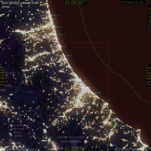
Analysis of Silvi night lights 2016
Square area 10x10 km:
 9.68%
9.68%90-99
10.79%80-89
3.49%70-79
5.24%60-69
3.33%50-59
3.02%40-49
3.81%30-39
5.56%20-29
21.9%10-19
25.56%0-9
7.62%Square area 50x50 km:
2.92%90-99
4.39%80-89
1.89%70-79
2.27%60-69
3.29%50-59
3.11%40-49
3.23%30-39
3.85%20-29
8.75%10-19
14.09%0-9
52.2%Clear (daylight) street map image can be seen on geolist.org.
Map coordinates:
43° 3' 56.4" North, 13° 24' 52.1" East
42° 32' 59.4" North, 14° 7' 3.3" East
42° 1' 47" North, 14° 49' 14.6" East
Some cities around Silvi sort by population:
• Pescara
12.3 km =7.6 mi,  145°
145°
• Montesilvano Marina
4.8 km =3 mi, 152°
• Roseto degli Abruzzi
15.9 km =9.9 mi,  328°
328°
• Sambuceto
15.4 km =9.6 mi,  158°
158°
• Penne
18.8 km =11.7 mi,  235°
235°
• Atri
10.9 km =6.8 mi,  285°
285°
• Pineto
7.8 km =4.8 mi, 327°
• Villa Raspa
11.8 km =7.3 mi, 152°
3166520 (p: 12,551)
Sources (retrieved 2019-11-25):
» Earth at Night: Flat Maps 2012, 2016