Atri night lights from space
Night Light of Atri (Abruzzo) from space (Italy) Src. Average luminocity for 10x10km area is 20.254% and for 50x50km: 23.611%.
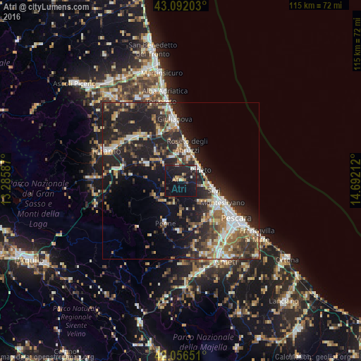
Analysis of Atri night lights 2016
Square area 10x10 km:
 0.63%
0.63%90-99
3.49%80-89
1.43%70-79
0.63%60-69
2.38%50-59
1.59%40-49
2.22%30-39
1.11%20-29
12.54%10-19
37.94%0-9
36.03%Square area 50x50 km:
3.13%90-99
4.51%80-89
2.02%70-79
2.38%60-69
3.38%50-59
3.16%40-49
3.31%30-39
4.19%20-29
10.88%10-19
16.11%0-9
46.94%Clear (daylight) street map image can be seen on geolist.org.
Map coordinates:
43° 5' 31.3" North, 13° 17' 9.1" East
42° 34' 35.1" North, 13° 59' 20.4" East
42° 3' 23.4" North, 14° 41' 31.6" East
Some cities around Atri sort by population:
• Montesilvano Marina
14.7 km =9.1 mi,  119°
119°
• Giulianova
19.8 km =12.3 mi,  354°
354°
• Roseto degli Abruzzi
10.8 km =6.7 mi,  11°
11°
• Silvi
10.9 km =6.8 mi,  105°
105°
• Penne
14.4 km =8.9 mi,  200°
200°
• Pineto
7.3 km =4.5 mi,  60°
60°
• San Nicolò a Tordino
20.6 km =12.8 mi,  310°
310°
• Villa Raspa
20.9 km =13 mi,  130°
130°
3182697 (p: 5,854)
Sources (retrieved 2019-11-25):
» Earth at Night: Flat Maps 2012, 2016