Bedizzole night lights from space
Night Light of Bedizzole (Lombardy) from space (Italy) Src. Average luminocity for 10x10km area is 55.1222% and for 50x50km: 36.2056%.
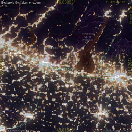
Analysis of Bedizzole night lights 2016
Square area 10x10 km:
 5.87%
5.87%90-99
9.05%80-89
4.44%70-79
7.94%60-69
7.14%50-59
13.49%40-49
19.37%30-39
26.51%20-29
6.19%10-19
0%0-9
0%Square area 50x50 km:
5.97%90-99
6.84%80-89
2.58%70-79
3.71%60-69
4.72%50-59
5.22%40-49
6.03%30-39
7.76%20-29
14.35%10-19
22.71%0-9
20.1%Clear (daylight) street map image can be seen on geolist.org.
Map coordinates:
46° 0' 3.5" North, 9° 43' 12.5" East
45° 30' 37.4" North, 10° 25' 23.8" East
45° 0' 55.8" North, 11° 7' 35" East
Some cities around Bedizzole sort by population:
• Rezzato
8.3 km =5.2 mi,  271°
271°
• Botticino
9 km =5.6 mi,  283°
283°
• Calcinato
6 km =3.7 mi,  190°
190°
• Piazza
0.1 km =0.1 mi,  151°
151°
• Gavardo-Sopraponte
8.9 km =5.5 mi,  9°
9°
• Molinetto
5.3 km =3.3 mi,  250°
250°
• Lonato
6.9 km =4.3 mi,  142°
142°
• Prevalle
4.6 km =2.9 mi,  358°
358°
6534215 (p: 9,320)
Sources (retrieved 2019-11-25):
» Earth at Night: Flat Maps 2012, 2016