Preganziol night lights from space
Night Light of Preganziol (Veneto) from space (Italy) Src. Average luminocity for 10x10km area is 65.3545% and for 50x50km: 46.7417%.
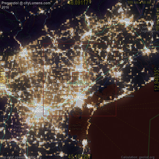
Analysis of Preganziol night lights 2016
Square area 10x10 km:
 8.64%
8.64%90-99
10.91%80-89
10%70-79
8.48%60-69
16.06%50-59
19.09%40-49
13.79%30-39
13.03%20-29
0%10-19
0%0-9
0%Square area 50x50 km:
6.91%90-99
8.8%80-89
4.54%70-79
5.48%60-69
8.13%50-59
10.29%40-49
8.62%30-39
7.89%20-29
14.62%10-19
14.3%0-9
10.43%Clear (daylight) street map image can be seen on geolist.org.
Map coordinates:
46° 5' 28.2" North, 11° 32' 2.8" East
45° 36' 5" North, 12° 14' 14" East
45° 6' 26.2" North, 12° 56' 25.3" East
Some cities around Preganziol sort by population:
• Treviso
7.3 km =4.5 mi,  2°
2°
• Mogliano Veneto
5.1 km =3.2 mi,  174°
174°
• Marcon-Gaggio-Colmello
6.3 km =3.9 mi,  130°
130°
• Casale sul Sile
7 km =4.3 mi,  94°
94°
• Quinto di Treviso
7.3 km =4.5 mi,  309°
309°
• Zero Branco
5.7 km =3.5 mi,  267°
267°
• Frescada
3 km =1.9 mi,  359°
359°
• Dosson
4.1 km =2.5 mi,  18°
18°
3169869 (p: 6,674)
Sources (retrieved 2019-11-25):
» Earth at Night: Flat Maps 2012, 2016