Portogruaro night lights from space
Night Light of Portogruaro (Veneto) from space (Italy) Src. Average luminocity for 10x10km area is 41.1794% and for 50x50km: 22.8578%.
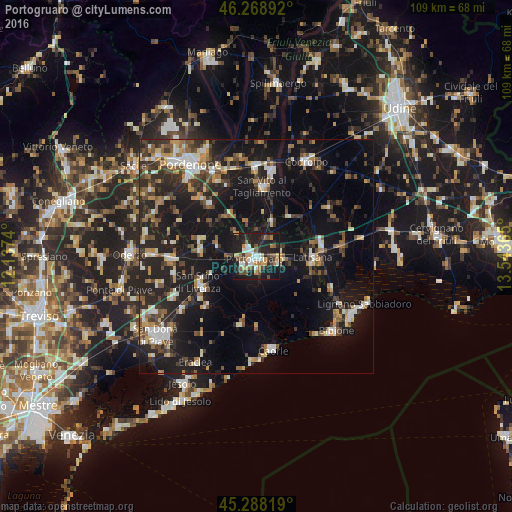
Analysis of Portogruaro night lights 2016
Square area 10x10 km:
 6.19%
6.19%90-99
6.51%80-89
3.97%70-79
5.24%60-69
5.56%50-59
6.98%40-49
7.14%30-39
3.33%20-29
17.62%10-19
36.51%0-9
0.95%Square area 50x50 km:
2.31%90-99
3.48%80-89
1.87%70-79
2.58%60-69
2.83%50-59
3.34%40-49
3.87%30-39
3.73%20-29
8.45%10-19
24.52%0-9
43.02%Clear (daylight) street map image can be seen on geolist.org.
Map coordinates:
46° 16' 8.1" North, 12° 8' 14.6" East
45° 46' 50.6" North, 12° 50' 25.9" East
45° 17' 17.5" North, 13° 32' 37.1" East
Some cities around Portogruaro sort by population:
• Rosa
16.8 km =10.4 mi,  8°
8°
• San Vito al Tagliamento
15.2 km =9.4 mi, 5°
• Fiume Veneto
18.3 km =11.4 mi,  334°
334°
• Latisana
12.9 km =8 mi,  95°
95°
• Concordia Sagittaria
2.5 km =1.6 mi,  211°
211°
• Motta di Livenza
18.3 km =11.4 mi,  268°
268°
• San Stino di Livenza
13.2 km =8.2 mi,  242°
242°
• Ceggia
18.6 km =11.6 mi, 235°
3170086 (p: 17,468)
Sources (retrieved 2019-11-25):
» Earth at Night: Flat Maps 2012, 2016