Ceggia night lights from space
Night Light of Ceggia (Veneto) from space (Italy) Src. Average luminocity for 10x10km area is 33.2758% and for 50x50km: 24.4144%.
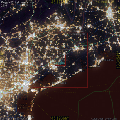
Analysis of Ceggia night lights 2016
Square area 10x10 km:
 2.73%
2.73%90-99
7.58%80-89
3.03%70-79
1.67%60-69
4.7%50-59
3.94%40-49
3.33%30-39
4.24%20-29
20.15%10-19
40.3%0-9
8.33%Square area 50x50 km:
2.08%90-99
3.72%80-89
2.24%70-79
2.52%60-69
2.84%50-59
3.61%40-49
4.09%30-39
4%20-29
12.18%10-19
27.78%0-9
34.94%Clear (daylight) street map image can be seen on geolist.org.
Map coordinates:
46° 10' 33.7" North, 11° 56' 21" East
45° 41' 13.2" North, 12° 38' 32.2" East
45° 11' 37.2" North, 13° 20' 43.5" East
Some cities around Ceggia sort by population:
• San Donà di Piave
8.6 km =5.3 mi,  222°
222°
• Oderzo
15.5 km =9.6 mi,  312°
312°
• Concordia Sagittaria
16.3 km =10.1 mi,  59°
59°
• Musile di Piave
10.8 km =6.7 mi,  226°
226°
• Motta di Livenza
10.3 km =6.4 mi,  343°
343°
• San Stino di Livenza
5.7 km =3.5 mi,  40°
40°
• Salgareda
12.1 km =7.5 mi,  279°
279°
• Noventa di Piave
9 km =5.6 mi,  250°
250°
3179220 (p: 5,493)
Sources (retrieved 2019-11-25):
» Earth at Night: Flat Maps 2012, 2016