Latisana night lights from space
Night Light of Latisana (Friuli Venezia Giulia) from space (Italy) Src. Average luminocity for 10x10km area is 25.1254% and for 50x50km: 15.7301%.
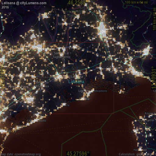
Analysis of Latisana night lights 2016
Square area 10x10 km:
 1.9%
1.9%90-99
3.81%80-89
0.95%70-79
2.54%60-69
4.44%50-59
4.6%40-49
5.08%30-39
1.43%20-29
6.98%10-19
40.16%0-9
28.1%Square area 50x50 km:
1.32%90-99
2.12%80-89
1.37%70-79
1.66%60-69
1.8%50-59
2.14%40-49
2.55%30-39
2.32%20-29
4.04%10-19
21.45%0-9
59.21%Clear (daylight) street map image can be seen on geolist.org.
Map coordinates:
46° 15' 24.8" North, 12° 18' 11" East
45° 46' 6.9" North, 13° 0' 22.2" East
45° 16' 33.5" North, 13° 42' 33.5" East
Some cities around Latisana sort by population:
• Portogruaro
12.9 km =8 mi,  275°
275°
• Rosa
20.8 km =12.9 mi,  329°
329°
• Codroipo
21.9 km =13.6 mi,  354°
354°
• San Vito al Tagliamento
20 km =12.4 mi, 325°
• Concordia Sagittaria
14.2 km =8.8 mi,  266°
266°
• Caorle
21.6 km =13.4 mi,  207°
207°
• San Giorgio di Nogaro
17.2 km =10.7 mi,  67°
67°
• Lignano Sabbiadoro
13.4 km =8.3 mi,  140°
140°
3175055 (p: 8,896)
Sources (retrieved 2019-11-25):
» Earth at Night: Flat Maps 2012, 2016