Motta di Livenza night lights from space
Night Light of Motta di Livenza (Veneto) from space (Italy) Src. Average luminocity for 10x10km area is 34.6333% and for 50x50km: 32.7978%.
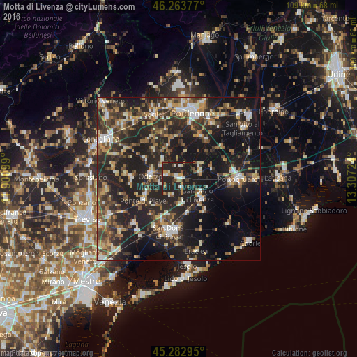
Analysis of Motta di Livenza night lights 2016
Square area 10x10 km:
 1.9%
1.9%90-99
6.35%80-89
3.33%70-79
6.67%60-69
3.17%50-59
2.86%40-49
6.19%30-39
1.27%20-29
21.75%10-19
46.51%0-9
0%Square area 50x50 km:
3.03%90-99
5.27%80-89
3.03%70-79
3.94%60-69
4.58%50-59
5.06%40-49
6.28%30-39
6.29%20-29
15.63%10-19
27.87%0-9
19.02%Clear (daylight) street map image can be seen on geolist.org.
Map coordinates:
46° 15' 49.6" North, 11° 54' 3.6" East
45° 46' 31.9" North, 12° 36' 14.8" East
45° 16' 58.6" North, 13° 18' 26.1" East
Some cities around Motta di Livenza sort by population:
• San Donà di Piave
16.4 km =10.2 mi,  189°
189°
• Oderzo
8.5 km =5.3 mi,  274°
274°
• Azzano Decimo
15.6 km =9.7 mi,  17°
17°
• San Stino di Livenza
8.7 km =5.4 mi,  129°
129°
• Brugnera
14.6 km =9.1 mi,  340°
340°
• Salgareda
11.9 km =7.4 mi,  228°
228°
• Ceggia
10.3 km =6.4 mi,  163°
163°
• Noventa di Piave
14 km =8.7 mi,  203°
203°
3172508 (p: 7,242)
Sources (retrieved 2019-11-25):
» Earth at Night: Flat Maps 2012, 2016