San Stino di Livenza night lights from space
Night Light of San Stino di Livenza (Veneto) from space (Italy) Src. Average luminocity for 10x10km area is 25.6061% and for 50x50km: 23.7443%.
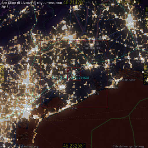
Analysis of San Stino di Livenza night lights 2016
Square area 10x10 km:
 2.27%
2.27%90-99
4.85%80-89
1.21%70-79
1.82%60-69
2.88%50-59
2.58%40-49
6.06%30-39
2.12%20-29
5.45%10-19
46.67%0-9
24.09%Square area 50x50 km:
1.91%90-99
3.57%80-89
2.01%70-79
2.6%60-69
2.86%50-59
3.38%40-49
4.11%30-39
3.7%20-29
12.3%10-19
26.98%0-9
36.59%Clear (daylight) street map image can be seen on geolist.org.
Map coordinates:
46° 12' 51.4" North, 11° 59' 11.7" East
45° 43' 32.1" North, 12° 41' 23" East
45° 13' 57.3" North, 13° 23' 34.2" East
Some cities around San Stino di Livenza sort by population:
• San Donà di Piave
14.2 km =8.8 mi,  221°
221°
• Portogruaro
13.2 km =8.2 mi,  62°
62°
• Concordia Sagittaria
11.1 km =6.9 mi,  69°
69°
• Musile di Piave
16.4 km =10.2 mi, 224°
• Motta di Livenza
8.7 km =5.4 mi,  309°
309°
• Salgareda
15.8 km =9.8 mi,  261°
261°
• Ceggia
5.7 km =3.5 mi, 220°
• Noventa di Piave
14.2 km =8.8 mi,  238°
238°
3167239 (p: 7,080)
Sources (retrieved 2019-11-25):
» Earth at Night: Flat Maps 2012, 2016