Fiume Veneto night lights from space
Night Light of Fiume Veneto (Friuli Venezia Giulia) from space (Italy) Src. Average luminocity for 10x10km area is 42.2351% and for 50x50km: 24.4409%.
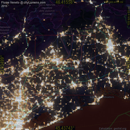
Analysis of Fiume Veneto night lights 2016
Square area 10x10 km:
 4.61%
4.61%90-99
6.4%80-89
3.57%70-79
8.04%60-69
6.7%50-59
3.87%40-49
10.42%30-39
10.71%20-29
17.11%10-19
25.3%0-9
3.27%Square area 50x50 km:
2.11%90-99
3.71%80-89
1.95%70-79
2.6%60-69
3.15%50-59
3.62%40-49
4.32%30-39
4.5%20-29
11.23%10-19
25.59%0-9
37.22%Clear (daylight) street map image can be seen on geolist.org.
Map coordinates:
46° 24' 56" North, 12° 2' 6" East
45° 55' 43.1" North, 12° 44' 17.2" East
45° 26' 14.7" North, 13° 26' 28.5" East
Some cities around Fiume Veneto sort by population:
• Pordenone
6.8 km =4.2 mi,  297°
297°
• Cordenons
6.8 km =4.2 mi,  334°
334°
• Rosa
10.3 km =6.4 mi,  88°
88°
• Porcia
10.2 km =6.3 mi,  292°
292°
• San Vito al Tagliamento
9.5 km =5.9 mi,  97°
97°
• Azzano Decimo
6.1 km =3.8 mi,  249°
249°
• Casarsa della Delizia
8.4 km =5.2 mi,  72°
72°
• Roveredo in Piano
12.8 km =8 mi,  314°
314°
3176927 (p: 9,313)
Sources (retrieved 2019-11-25):
» Earth at Night: Flat Maps 2012, 2016