Pogliano Milanese night lights from space
Night Light of Pogliano Milanese (Lombardy) from space (Italy) Src. Average luminocity for 10x10km area is 91.0606% and for 50x50km: 70.7104%.
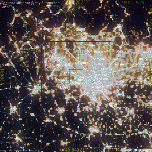
Analysis of Pogliano Milanese night lights 2016
Square area 10x10 km:
 34.39%
90-99
35.76%80-89
11.36%70-79
7.73%60-69
6.97%50-59
3.79%40-49
0%30-39
0%20-29
0%10-19
0%0-9
0%Square area 50x50 km:
27.32%90-99
17.48%80-89
6.49%70-79
7.64%60-69
8.07%50-59
5.05%40-49
5.03%30-39
5.69%20-29
8.44%10-19
6.39%0-9
2.39%Clear (daylight) street map image can be seen on geolist.org.
Map coordinates:
46° 1' 41.5" North, 8° 17' 27.3" East
45° 32' 16.3" North, 8° 59' 38.5" East
45° 2' 35.6" North, 9° 41' 49.8" East
Some cities around Pogliano Milanese sort by population:
• Rho
3.6 km =2.2 mi,  99°
99°
• Parabiago
4.5 km =2.8 mi,  303°
303°
• Lainate
4.6 km =2.9 mi,  34°
34°
• Cornaredo
4.8 km =3 mi,  147°
147°
• Nerviano
2.1 km =1.3 mi,  326°
326°
• Sedriano
5.5 km =3.4 mi,  198°
198°
• Vanzago
1.4 km =0.9 mi,  189°
189°
• Pregnana Milanese
2.6 km =1.6 mi,  157°
157°
3170422 (p: 8,057)
Sources (retrieved 2019-11-25):
» Earth at Night: Flat Maps 2012, 2016