Sedriano night lights from space
Night Light of Sedriano (Lombardy) from space (Italy) Src. Average luminocity for 10x10km area is 76.8159% and for 50x50km: 64.6782%.
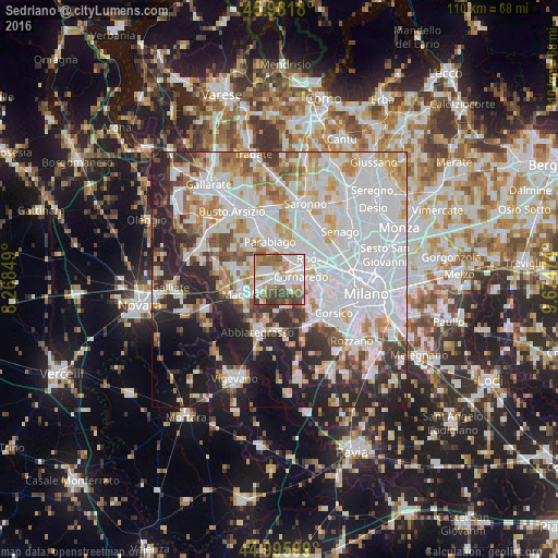
Analysis of Sedriano night lights 2016
Square area 10x10 km:
 22.22%
90-99
23.65%80-89
6.19%70-79
6.51%60-69
13.97%50-59
11.11%40-49
9.05%30-39
7.3%20-29
0%10-19
0%0-9
0%Square area 50x50 km:
25.27%90-99
15.41%80-89
5.86%70-79
6.37%60-69
6.73%50-59
4.09%40-49
4.34%30-39
5.22%20-29
10.96%10-19
10.85%0-9
4.91%Clear (daylight) street map image can be seen on geolist.org.
Map coordinates:
45° 58' 54.5" North, 8° 16' 6.6" East
45° 29' 27.8" North, 8° 58' 17.8" East
44° 59' 45.6" North, 9° 40' 29.1" East
Some cities around Sedriano sort by population:
• Cornaredo
4.5 km =2.8 mi,  75°
75°
• Bareggio
2.4 km =1.5 mi,  122°
122°
• Corbetta
4.9 km =3 mi,  237°
237°
• Arluno
2.7 km =1.7 mi,  301°
301°
• Vittuone
1.6 km =1 mi,  257°
257°
• Pogliano Milanese
5.5 km =3.4 mi,  18°
18°
• Vanzago
4.1 km =2.5 mi, 21°
• Pregnana Milanese
3.9 km =2.4 mi,  44°
44°
3166822 (p: 10,833)
Sources (retrieved 2019-11-25):
» Earth at Night: Flat Maps 2012, 2016