Paullo night lights from space
Night Light of Paullo (Lombardy) from space (Italy) Src. Average luminocity for 10x10km area is 55.2048% and for 50x50km: 61.0226%.
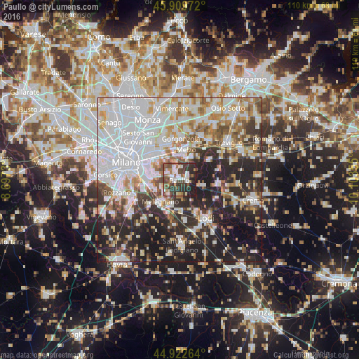
Analysis of Paullo night lights 2016
Square area 10x10 km:
 9.37%
9.37%90-99
13.02%80-89
5.08%70-79
4.29%60-69
5.56%50-59
9.21%40-49
13.17%30-39
18.1%20-29
16.35%10-19
5.87%0-9
0%Square area 50x50 km:
21.79%90-99
13.57%80-89
5.06%70-79
6.01%60-69
6.23%50-59
5.54%40-49
5.2%30-39
6.54%20-29
15.22%10-19
13.06%0-9
1.78%Clear (daylight) street map image can be seen on geolist.org.
Map coordinates:
45° 54' 35" North, 8° 41' 50.3" East
45° 25' 6" North, 9° 24' 1.5" East
44° 55' 21.5" North, 10° 6' 12.8" East
Some cities around Paullo sort by population:
• San Giuliano Milanese
9 km =5.6 mi,  252°
252°
• Melzo
9 km =5.6 mi,  9°
9°
• Melegnano
9 km =5.6 mi,  221°
221°
• Bettola-Zeloforomagno
7.3 km =4.5 mi,  280°
280°
• Vignate
9.2 km =5.7 mi,  348°
348°
• Spino d'Adda
7 km =4.3 mi,  106°
106°
• Zelo Buon Persico
2.6 km =1.6 mi, 106°
• Pantigliate
4.2 km =2.6 mi,  296°
296°
3171370 (p: 10,877)
Sources (retrieved 2019-11-25):
» Earth at Night: Flat Maps 2012, 2016