Melegnano night lights from space
Night Light of Melegnano (Lombardy) from space (Italy) Src. Average luminocity for 10x10km area is 60.2937% and for 50x50km: 55.3349%.
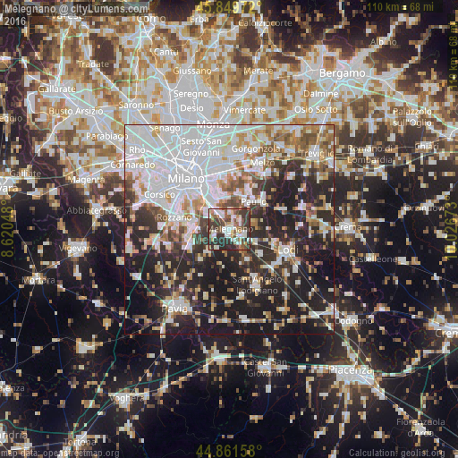
Analysis of Melegnano night lights 2016
Square area 10x10 km:
 11.59%
90-99
15.4%80-89
5.71%70-79
5.08%60-69
4.29%50-59
13.33%40-49
10.63%30-39
20.32%20-29
13.65%10-19
0%0-9
0%Square area 50x50 km:
18.43%90-99
12.11%80-89
4.61%70-79
4.65%60-69
5.73%50-59
5.58%40-49
4.87%30-39
6.29%20-29
15.61%10-19
19.06%0-9
3.08%Clear (daylight) street map image can be seen on geolist.org.
Map coordinates:
45° 50' 59" North, 8° 37' 13.7" East
45° 21' 28.1" North, 9° 19' 25" East
44° 51' 41.7" North, 10° 1' 36.2" East
Some cities around Melegnano sort by population:
• San Giuliano Milanese
4.8 km =3 mi,  327°
327°
• San Donato Milanese
7.3 km =4.5 mi,  323°
323°
• Bettola-Zeloforomagno
8.2 km =5.1 mi,  351°
351°
• Opera
9 km =5.6 mi,  281°
281°
• Paullo
9 km =5.6 mi,  41°
41°
• Locate di Triulzi
7.7 km =4.8 mi,  269°
269°
• Pantigliate
8.9 km =5.5 mi,  14°
14°
• Tavazzano
7.2 km =4.5 mi,  117°
117°
3173631 (p: 16,707)
Sources (retrieved 2019-11-25):
» Earth at Night: Flat Maps 2012, 2016