Spino d'Adda night lights from space
Night Light of Spino d'Adda (Lombardy) from space (Italy) Src. Average luminocity for 10x10km area is 32.8016% and for 50x50km: 53.8724%.
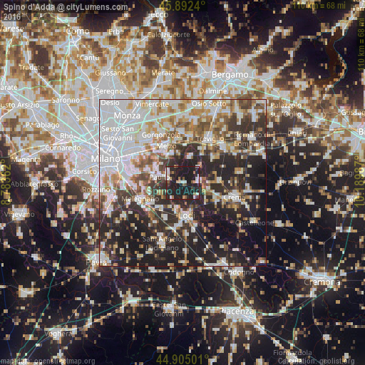
Analysis of Spino d'Adda night lights 2016
Square area 10x10 km:
 4.44%
4.44%90-99
5.56%80-89
2.7%70-79
1.75%60-69
3.65%50-59
3.02%40-49
1.43%30-39
4.92%20-29
20.79%10-19
51.75%0-9
0%Square area 50x50 km:
16.49%90-99
11.31%80-89
4.46%70-79
5.43%60-69
6.04%50-59
5.53%40-49
5.56%30-39
7.14%20-29
16.4%10-19
17%0-9
4.65%Clear (daylight) street map image can be seen on geolist.org.
Map coordinates:
45° 53' 32.6" North, 8° 47' 1" East
45° 24' 3.1" North, 9° 29' 12.3" East
44° 54' 18" North, 10° 11' 23.5" East
Some cities around Spino d'Adda sort by population:
• Lodi
10.2 km =6.3 mi,  173°
173°
• Paullo
7 km =4.3 mi,  286°
286°
• Pandino
5.1 km =3.2 mi,  84°
84°
• Lodi Vecchio
12 km =7.5 mi,  206°
206°
• Rivolta d'Adda
7.9 km =4.9 mi,  14°
14°
• Zelo Buon Persico
4.5 km =2.8 mi, 285°
• Pantigliate
11.2 km =7 mi, 290°
• Tavazzano
10.3 km =6.4 mi,  218°
218°
3166241 (p: 6,584)
Sources (retrieved 2019-11-25):
» Earth at Night: Flat Maps 2012, 2016