Pantigliate night lights from space
Night Light of Pantigliate (Lombardy) from space (Italy) Src. Average luminocity for 10x10km area is 68.8095% and for 50x50km: 64.223%.
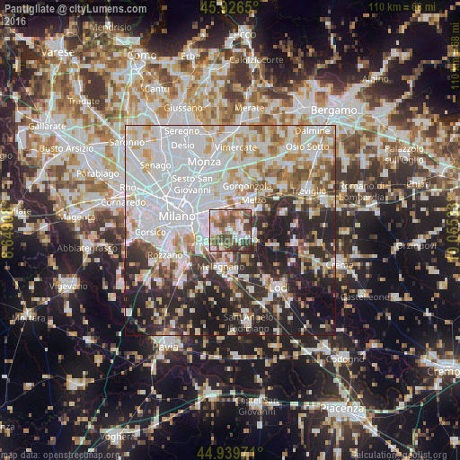
Analysis of Pantigliate night lights 2016
Square area 10x10 km:
 13.33%
90-99
17.78%80-89
5.4%70-79
7.94%60-69
12.38%50-59
16.35%40-49
18.41%30-39
7.46%20-29
0.95%10-19
0%0-9
0%Square area 50x50 km:
24.36%90-99
14.91%80-89
5.47%70-79
6.21%60-69
6.34%50-59
5.22%40-49
4.62%30-39
5.67%20-29
14.04%10-19
11.55%0-9
1.62%Clear (daylight) street map image can be seen on geolist.org.
Map coordinates:
45° 55' 35.4" North, 8° 38' 56.7" East
45° 26' 6.9" North, 9° 21' 7.9" East
44° 56' 23" North, 10° 3' 19.2" East
Some cities around Pantigliate sort by population:
• Pioltello
7.6 km =4.7 mi,  347°
347°
• San Giuliano Milanese
6.6 km =4.1 mi,  226°
226°
• San Donato Milanese
7.1 km =4.4 mi,  247°
247°
• Segrate
7.6 km =4.7 mi,  326°
326°
• Bettola-Zeloforomagno
3.4 km =2.1 mi,  261°
261°
• Paullo
4.2 km =2.6 mi,  116°
116°
• Vignate
7.4 km =4.6 mi,  15°
15°
• Zelo Buon Persico
6.7 km =4.2 mi,  112°
112°
3171502 (p: 5,817)
Sources (retrieved 2019-11-25):
» Earth at Night: Flat Maps 2012, 2016