Morlupo night lights from space
Night Light of Morlupo (Latium) from space (Italy) Src. Average luminocity for 10x10km area is 25.5712% and for 50x50km: 27.6521%.
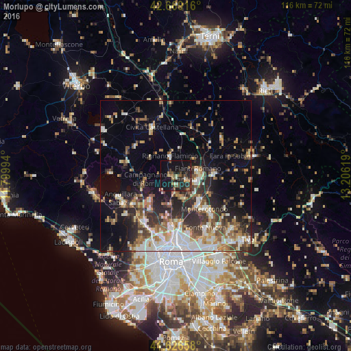
Analysis of Morlupo night lights 2016
Square area 10x10 km:
 0.3%
0.3%90-99
2.27%80-89
1.97%70-79
2.58%60-69
3.79%50-59
6.67%40-49
3.64%30-39
6.21%20-29
14.85%10-19
34.85%0-9
22.88%Square area 50x50 km:
4.27%90-99
5.36%80-89
3.08%70-79
3.04%60-69
3.44%50-59
3.91%40-49
4.03%30-39
4.47%20-29
8.07%10-19
10.84%0-9
49.49%Clear (daylight) street map image can be seen on geolist.org.
Map coordinates:
42° 40' 9" North, 11° 47' 59.8" East
42° 9' 0.1" North, 12° 30' 11" East
41° 37' 35.7" North, 13° 12' 22.3" East
Some cities around Morlupo sort by population:
• Monterotondo
14.6 km =9.1 mi,  138°
138°
• Fiano Romano
7.6 km =4.7 mi,  85°
85°
• Campagnano di Roma
10.8 km =6.7 mi,  261°
261°
• Rignano Flaminio
6.4 km =4 mi,  343°
343°
• Riano
6.4 km =4 mi,  171°
171°
• Cesano
16.1 km =10 mi,  238°
238°
• Capena
3.6 km =2.2 mi,  103°
103°
• Formello
13.2 km =8.2 mi,  222°
222°
3172586 (p: 6,424)
Sources (retrieved 2019-11-25):
» Earth at Night: Flat Maps 2012, 2016