Cesano night lights from space
Night Light of Cesano (Latium) from space (Italy) Src. Average luminocity for 10x10km area is 45.2413% and for 50x50km: 33.0011%.
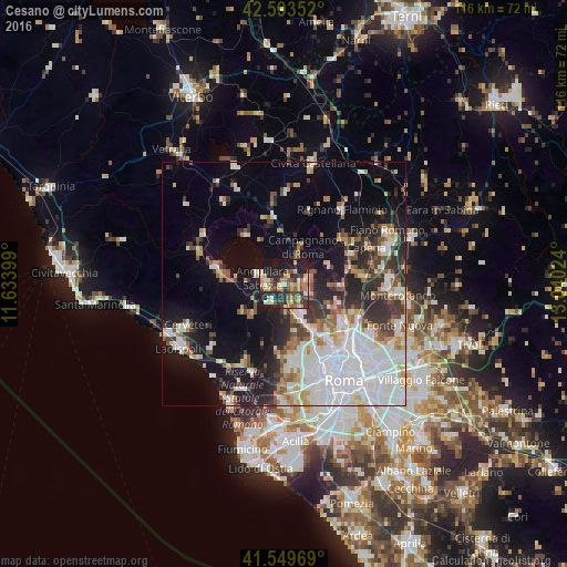
Analysis of Cesano night lights 2016
Square area 10x10 km:
 3.02%
3.02%90-99
8.73%80-89
8.1%70-79
7.3%60-69
5.56%50-59
6.35%40-49
8.41%30-39
7.14%20-29
17.62%10-19
27.78%0-9
0%Square area 50x50 km:
9.39%90-99
7.33%80-89
3.08%70-79
2.98%60-69
2.69%50-59
3.37%40-49
3.02%30-39
3.91%20-29
7.6%10-19
13.01%0-9
43.62%Clear (daylight) street map image can be seen on geolist.org.
Map coordinates:
42° 35' 36.7" North, 11° 38' 2.4" East
42° 4' 25.5" North, 12° 20' 13.6" East
41° 32' 58.9" North, 13° 2' 24.9" East
Some cities around Cesano sort by population:
• Anguillara Sabazia
4.5 km =2.8 mi,  277°
277°
• Bracciano
14.5 km =9 mi, 282°
• Campagnano di Roma
7.5 km =4.7 mi,  23°
23°
• Riano
14.8 km =9.2 mi,  81°
81°
• Morlupo
16.1 km =10 mi,  58°
58°
• Ara Nova
17.6 km =10.9 mi,  207°
207°
• Manziana
18.6 km =11.6 mi,  289°
289°
• Formello
4.9 km =3 mi,  104°
104°
3178974 (p: 6,549)
Sources (retrieved 2019-11-25):
» Earth at Night: Flat Maps 2012, 2016