Fiano Romano night lights from space
Night Light of Fiano Romano (Latium) from space (Italy) Src. Average luminocity for 10x10km area is 39.4288% and for 50x50km: 26.6634%.
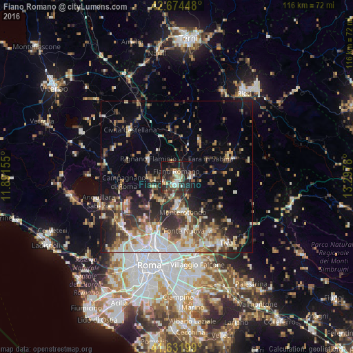
Analysis of Fiano Romano night lights 2016
Square area 10x10 km:
 4.09%
4.09%90-99
7.42%80-89
3.94%70-79
4.09%60-69
4.7%50-59
5.45%40-49
6.52%30-39
10.61%20-29
19.7%10-19
30.15%0-9
3.33%Square area 50x50 km:
3.83%90-99
5.16%80-89
3.06%70-79
3.04%60-69
3.32%50-59
3.78%40-49
4.03%30-39
4.52%20-29
8.08%10-19
10.91%0-9
50.27%Clear (daylight) street map image can be seen on geolist.org.
Map coordinates:
42° 40' 28.1" North, 11° 53' 29.6" East
42° 9' 19.4" North, 12° 35' 40.8" East
41° 37' 55.2" North, 13° 17' 52.1" East
Some cities around Fiano Romano sort by population:
• Monterotondo
11.7 km =7.3 mi,  169°
169°
• Tor Lupara
17.6 km =10.9 mi, 173°
• Mentana
14 km =8.7 mi,  162°
162°
• Rignano Flaminio
10.9 km =6.8 mi,  300°
300°
• Riano
9.5 km =5.9 mi,  223°
223°
• Morlupo
7.6 km =4.7 mi,  265°
265°
• Palombara Sabina
17.1 km =10.6 mi,  124°
124°
• Capena
4.3 km =2.7 mi,  250°
250°
3177046 (p: 11,417)
Sources (retrieved 2019-11-25):
» Earth at Night: Flat Maps 2012, 2016