Formello night lights from space
Night Light of Formello (Latium) from space (Italy) Src. Average luminocity for 10x10km area is 44.6841% and for 50x50km: 37.2405%.
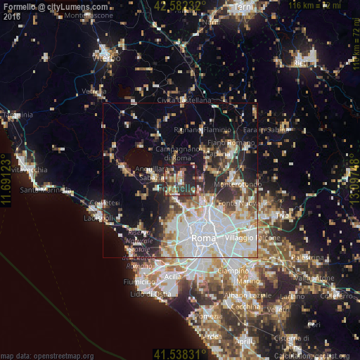
Analysis of Formello night lights 2016
Square area 10x10 km:
 2.54%
2.54%90-99
7.62%80-89
4.76%70-79
5.71%60-69
7.94%50-59
7.78%40-49
10.32%30-39
11.75%20-29
23.65%10-19
17.94%0-9
0%Square area 50x50 km:
10.58%90-99
8.46%80-89
3.66%70-79
3.7%60-69
3.2%50-59
3.71%40-49
3.31%30-39
4.24%20-29
8.34%10-19
13.08%0-9
37.72%Clear (daylight) street map image can be seen on geolist.org.
Map coordinates:
42° 34' 56.4" North, 11° 41' 28.4" East
42° 3' 44.9" North, 12° 23' 39.7" East
41° 32' 17.9" North, 13° 5' 50.9" East
Some cities around Formello sort by population:
• Anguillara Sabazia
9.3 km =5.8 mi,  281°
281°
• Campagnano di Roma
8.3 km =5.2 mi,  348°
348°
• Rignano Flaminio
17.4 km =10.8 mi,  24°
24°
• Riano
10.5 km =6.5 mi,  70°
70°
• Cesano
4.9 km =3 mi, 284°
• Morlupo
13.2 km =8.2 mi,  42°
42°
• Capena
15.3 km =9.5 mi,  54°
54°
• Vatican City, VA
18.4 km =11.4 mi,  164°
164°
3176739 (p: 5,143)
Sources (retrieved 2019-11-25):
» Earth at Night: Flat Maps 2012, 2016