Campagnano di Roma night lights from space
Night Light of Campagnano di Roma (Latium) from space (Italy) Src. Average luminocity for 10x10km area is 14.8939% and for 50x50km: 27.8419%.
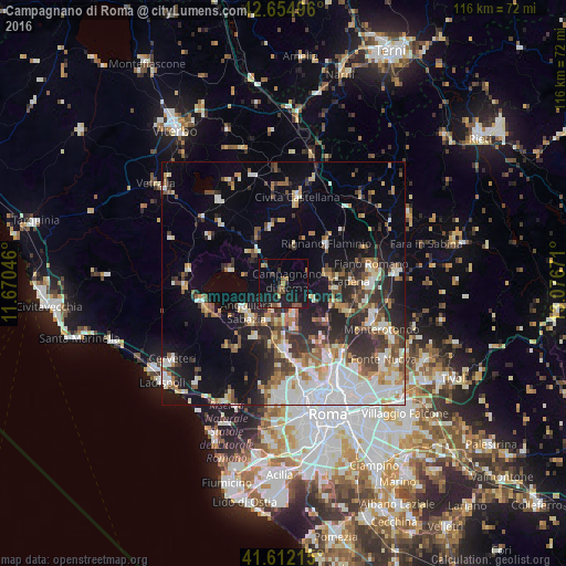
Analysis of Campagnano di Roma night lights 2016
Square area 10x10 km:
 0%
0%90-99
0%80-89
1.06%70-79
1.82%60-69
0.91%50-59
5%40-49
1.52%30-39
2.12%20-29
5.61%10-19
27.27%0-9
54.7%Square area 50x50 km:
5.5%90-99
5.78%80-89
2.89%70-79
2.77%60-69
2.88%50-59
3.6%40-49
3.22%30-39
3.96%20-29
7.46%10-19
12.04%0-9
49.91%Clear (daylight) street map image can be seen on geolist.org.
Map coordinates:
42° 39' 17.9" North, 11° 40' 13.7" East
42° 8' 8.5" North, 12° 22' 24.9" East
41° 36' 43.7" North, 13° 4' 36.2" East
Some cities around Campagnano di Roma sort by population:
• Anguillara Sabazia
9.7 km =6 mi,  229°
229°
• Rignano Flaminio
11.8 km =7.3 mi,  48°
48°
• Riano
12.5 km =7.8 mi,  111°
111°
• Cesano
7.5 km =4.7 mi,  203°
203°
• Morlupo
10.8 km =6.7 mi,  81°
81°
• Nepi
12.1 km =7.5 mi,  348°
348°
• Capena
14.2 km =8.8 mi,  86°
86°
• Formello
8.3 km =5.2 mi,  168°
168°
3181061 (p: 7,179)
Sources (retrieved 2019-11-25):
» Earth at Night: Flat Maps 2012, 2016